The forerunner of the Rocky Mountain Hydrologic Research Center (RMHRC) was the Rocky Mountain Hydraulic Laboratory (RMHL) organized under the laws of the State of Colorado on September 5, 1945. Unlike other outdoor hydraulic laboratories, it had no predecessor nor any sponsoring agency or institution to give it a start. In fact, the site was discovered by happenstance. Chesley Posey, one of the founding fathers of the laboratory, discovered the site while hiking in the mountains south of Estes Park, Colorado in the early 1940s.
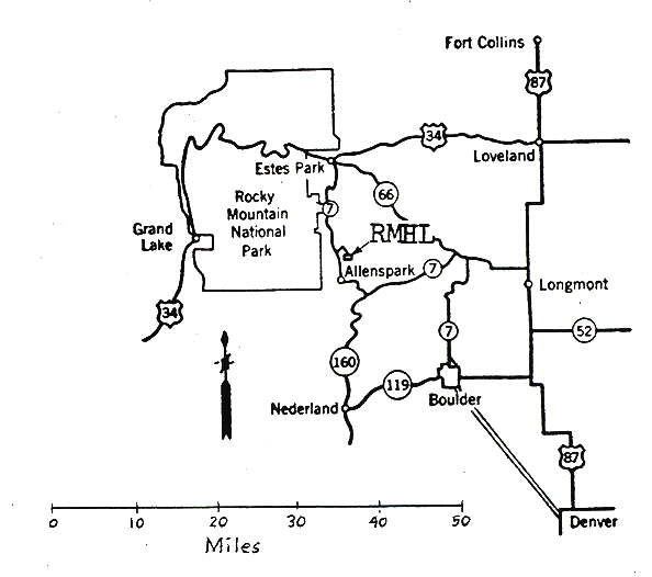
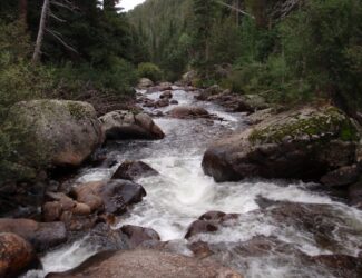
The site was on the North St. Vrain Creek below Highway 7 near Allenspark, Colorado. The North St.Vrain Creek had a fall of nearly eighty feet (24 m) in a quarter of a mile (400 m) and owing to the shape of the channel and extent of floodplain the creek could easily be diverted to supply water to various flumes and weirs. The flow is well over 100 cubic-feet per second (2.8 m3/s) in the early summer and seldom is less than 30 cubic-feet per second (0.8 m3/s) providing adequate flow for running outdoor hydraulic experiments. Gerard H. Matthes, principal engineer of the U.S. Waterways Experiment Station at Vicksburg, Mississippi, who had visited many European laboratories, agreed on its suitability, and said it was the best natural site he had ever seen.
Several hydraulic flumes were constructed at this 20-acre site alongside the North St. Vrain Creek, and portions of those flumes remain today. Initial research in the 1950s was focused on understanding bridge scour, scour under drilling barges, and underwater tanks. Later in the 1960s, research focused on open channel hydraulics and classes on hydraulics were held in a multipurpose building on site [1996, Colorado Water Resources Research Institute, Special Report No. 11].
During the 1970s and 1980s, the hydraulic research activity declined but the site has been used for more diverse research focusing on stream processes and aquatic habitat. In 1991, the name was changed to the Rocky Mountain Hydrologic Research Center to reflect new research goals of conducting a broad range of hydrologic and environmental science investigations in this headwater area of the Rocky Mountains [see 1996, Colorado Water Resources Research Institute, Special Report No. 11 for a list of scientific papers]. As part of the educational purpose of the RMHRC, an informal scientific meeting has been held annually for 74 years. It has included a wide range of topics related to hydrology (see programs listed under the Meetings Tab).
In 2007, five historical structures on the RMHL site along the North St. Vrain Creek were designated as historical landmarks by Boulder County:
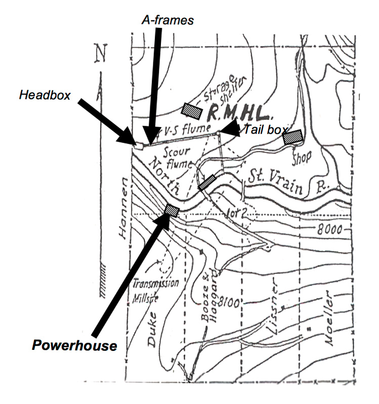
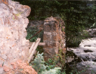
1. Powerhouse. Part of the site had once been used in the early 1900s to generate electricity for potential gold-mining operations near Allenspark. Portions of a powerhouse foundation on the south bank of the creek, remnants of the diversion ditch, and some parts of wooden trestles are still on the south side of the North St. Vrain Creek.
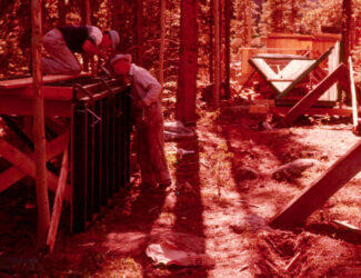
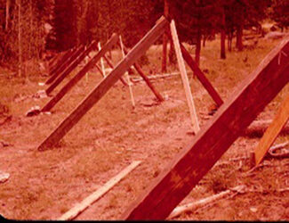
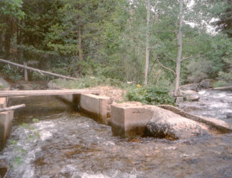
2. Variable slope flume. Several remnants of a 400-foot V-shaped, variable-slope flume exist on the site.
The first V-shape section of the flume is covered with sheet metal. It was constructed using concrete below ground and wood above ground. It is approximately a square box about 8 ft (2.4 m) on each side and 8 feet (2.4 m) deep into the ground. When full, it supplied water to the variable-slope flume with a triangular cross section. The head box received water via a short half-circle delivery flume (with galvanized sheet metal bottom) from the upstream diversion dam. Attached to the south side of the head box is a diversion or shunt box that allowed specific amounts of water to flow back to the North St. Vrain Creek and thus was a control to ensure that the variable-slope flume received the desired water discharge for each experimental run.
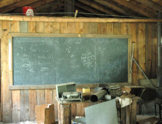
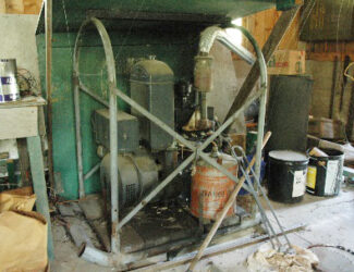
3. Multipurpose building or Shop. A wooden frame building (720 sq. ft., 67 m2) with board and batten siding was built to serve as a shop, classroom, bunkroom, and dining area. There are old hand tools, a generator for electricity, scientific instruments, a stove, and icebox, and a black board in the classroom area provided necessities for on-site researchers.

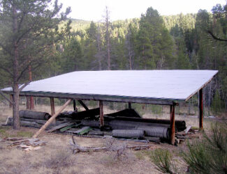
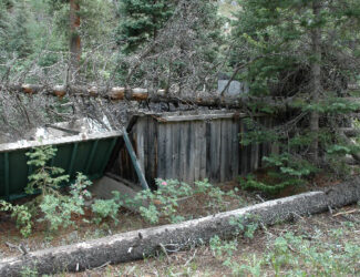
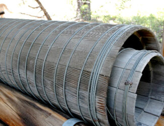
4. Storage shelter. An open sided structure was built for storing supplies and various parts used to operate the flumes. This shed now contains historic wood pipe that was made using wooden-barrel type construction. The pipes are about 2-3 feet (0.6-0.9 m) in diameter and 10-20 feet (3-6 m) long.
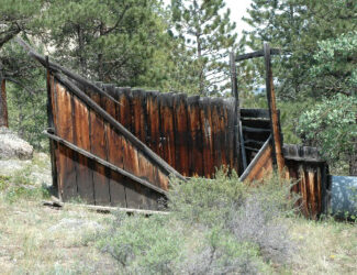
5. Scour Flume. The flume was constructed from concrete and located along the north bank of the North St. Vrain Creek. This flume had a smaller diversion dam separate from the main diversion dam for the variable-slope flume. It is located near the abutments for an old car bridge (now dismantled for safety reasons) and is constructed entirely of concrete, with recessed slots in the concrete for boards to control the water slope. Flow was adjusted using a shunt gate at the side of the flume.
The land and the stream have had little disturbance in the last 50 years. Work began on restoring the scour flume in 2010 and 2011, but a major flood in 2013 caused major damage, which has not been repaired.
By 2021, it was apparent that research potential at the site was increasingly limited due to several factors, including the decline of the structures and site accessibility. It was decided by the Board of Trustees that the land would be sold, and the proceeds be used to provide scholarships for students.